|
|
A closer look at South Asia Advanced GIS
Spring 2003
|
|
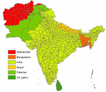
| Digitization |
Introduction This project includes digitizing the district boundaries of India and creating several maps for the South Asian countries in general. This project was undertaken as partial fulfillment for course completion in Advanced GIS for Spring 2003. Major countries in South Asia include Afghanistan, Bangladesh, India, Nepal, Pakistan, and Sri Lanka. The Provincial boundaries of these countries are already available in digital format and were downloaded from the Geocommunity website. However, district boundaries for none of these countries are available in digital format. This project is aimed at digitizing all the district boundaries of India and the dealing with the problems and solutions therein. |